

A voucher for 6 months toll pass at Bathampton Toll Bridge.
Antike Landkarten kaufen
189 Los(e)
- Liste
- Galerie
-
189 Los(e)/Seite

Los 7
Table Globe
Table Globe, paper printed and described in German on original ebonized stand around 1900. 40 cm high.

Asimov (Isaac) Foundation, first edition, toning to page margins, original boards (Currey's variant B), dust-jacket, some nicks and tears along ed...

Los 9
Columbus Globe
Columbus Globe, paper with colour printed card, on metal base. Berlin around 1960.

Los 11
6 MetLife & Peanuts Posters
Group of six posters relating to MetLife and the Peanuts gang: one MetLife advertising campaign proposal for a free kite; one United States map sh...

Circuit Maps signed by Michele Alboreto and Nelson Piquet, one circuit Kyalami, annotated in blue pen and signed by Nelson Piquet in blue pen,30 x...

Charles Schulz (American, 1922-2000). Original ink on paper drawing depicting Snoopy as the Flying Ace atop his doghouse, ca. 1970s. Signed along ...

Charles Schulz (American, 1922-2000). Original ink on paper drawing depicting Snoopy and Charlie visiting Lucy's therapy stand, ca. 1970s. Signed ...

Los 34
CHILDREN'S HAIRCUT AT HOME
At home haircut for up to 3 children at a mutually agreed time by a professional hairdresser (within a 1-mile radius of Bathford).

Charles Schulz (American, 1922-2000). Original ink on paper drawing depicting Schroeder at his piano. Signed along the lower right. With a certifi...

Charles Schulz (American, 1922-2000). Original ink on paper drawing of Linus with his beloved blanket. Signed along the lower right. With a certif...

Los 40
PHYSICS TUITION SESSION
A tuition session with a senior lecturer of physics from Bristol University (within a 1-mile radius of Bathford)

Charles Graham (American, 1852-1911). Hand-colored wood engraving titled "Sketches from Minneapolis, Minnesota" depicting Lake Minnetonka, the por...

Hand-colored engraving titled "St. Paul, From Dayton's Bluff," from the book "Picturesque America," published in 1874. Depicting a steamship on th...

Group of three items relating to Camp Snoopy. One gift bag from Snoopy's Gallery and Gift Shop and one gift bag from Minnesota Camp Snoopy. One ca...

17th Old Print Antique Original Color Gravure Attack Boulogne-sur-mer Jean 1788, Engraving - paper, Print, Author - Antoine Louis Francois Sergent...

The Isle of Skye, situated on the west coast of Scotland, is a captivating destination renowned for its breathtaking natural beauty and rich histo...

Los 87
Portrait of Charles de Cossé, Count of Brissac (1505/6-1563) French Soldier, Courtier & Marshal
Portrait of Charles de Cossé, Count of Brissac (1505/6-1563) French Soldier, Courtier & Marshal of France, Engraving - paper, Print, 1788 year, Au...
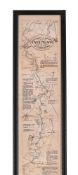
THE OARSMANS AND ANGLERS MAP OF THE THAMES Mounted, framed and glazed 175 x 14cm overall

Forster (E.M.) Howards End, first edition, second issue with 12pp. publisher's advertisements at end, bookplate (partially removed), light spottin...

Hand-colored map depicting Minnesota and the un-unified Dakota territories. Parts of Wisconsin and Iowa are seen in the margins. Surrounded by a b...

Los 111
County Map of Minnesota ca. 1877
Antique county map of the state of Minnesota, ca. 1877. Hand-colored in red, blue, and pink. Surrounded by a decorative border of ripe grape vines...

One group photograph depicting a postmaster's convention, ca. 1926. Inscribed "Postmaster's Convention, Curtis Hotel, June 18, 1926, Minneapolis, ...

Los 151
Nationalsozialismus -
Nationalsozialismus - Konzentrationslager - Plan obozu Koncentracyjnego "Gusen" Austrii kolo Lincu. 1:2880. Lichtdruck. Gezeichnet v. M. Kurasniew...

Los 171
Kelvin & Hughes Compass
Kelvin & Hughes Compass, in metal box. Movable. 20th Century. 8 cm diameter.

Tey (Josephine) The Franchise Affair, first edition, original boards, dust-jacket, light creasing, some nicks and short closed tears to edges, lig...

Edward Curtis (American, 1868-1952). Photogravure labeled "Members of the Expedition on St. Matthew Island" depicting three views of various membe...

After Michael Drayton (British, 1563-1631) - An etching on paper and hand coloured map of Glocestershyre (sic - Gloucestershire), from the poetic ...

Printed map and political poster headed as "Alcatraz - Indian Land" depicting Alcatraz Island and the events that occurred during the occupation b...

Engraving with text depicting a bustling Native American market. From Theodor de Bry (Netherlandish, 1528-1598), Thomas Hariot (British, ca. 1560-...

1st millennium B.C. A round-section rod coiled and partly flattened to form a hair ornament. See Taylor, J.T., Bronze Age Goldwork of the British ...

Los 309
A PAIR OF REGENCY G. & J. CARY'S CELESTIAL AND TERRESTRIAL FLOOR GLOBESLondon, first quarter 19t...
A PAIR OF REGENCY G. & J. CARY'S CELESTIAL AND TERRESTRIAL FLOOR GLOBES London, first quarter 19th century The celestial globe with cartouche read...
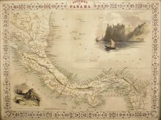
A 19th century circa 1850 Isthmus of Panama map by J. Rapkin. The illustrations by H. Warren, drawn and engraved by J. Rapkin and J. Wrightson. T...

Los 379
"Untitled" Print.
iMeasures 9.24 x 9.24Printed circa 1970sVerso is blank.Mounted to archival quality paper.

A 19th century circa 1850 map of Scotland. The map was illustrated by N. Whittock, drawn and engraved by J Rapkin. The map features excellent deta...

Los 465
David Roberts Print
19th century A.D. Printed map of Egypt and Nubia with locations marked of the sketches of David Roberts, RA on his 1849 expedition; mounted in a g...

Jan VAN CAMPENHOUT (1907-1972) 'City view by Night'Dimensions: (W:60 x H:70 cm)

Los 479
"Untitled" Print.
iMeasures 9.24 x 9.24Printed circa 1970sVerso is blank.Mounted to archival quality paper.

Los 485
Asien - Indonesien -
Asien - Indonesien - Molluken. "Moluccae Insulae celeberrimae". Mit altem Grenz- und Flächenkolorit, Kupferstichkarte, G. Blaeu in Amsterdam, um 1...

Australien und Ozeanien - Sotzmann, Daniel Friedrich. Karte des Grossen Oceans gewöhnlich Das Süd Meer genannt, nebst allen neuen Entdeckungen in ...

Taschen - Joan Blaeu Atlas Maior of 1665 hardback books with sleeve. Two reprinted collections of maps by Joan Blaeu comprising of Anglia, Scotia ...

Los 511
Deutschland - Berlin - Britz, N.
Deutschland - Berlin - Britz, N. Plan vom Dorf und Schloss zu Glienicke bei Potsdam. Manuskriptkarte von N. Britz, Berlin, um 1875. Blattgröße: 39...

Los 519
Deutschland - München - Hollar,
Deutschland - München - Hollar, Wenzel. Monachium avilica sedes Ducum Bavariae. Gesamtansicht aus der Vogelschau. Kupferstich von WH (Wenzel Holla...

Disneyland Cinderella castle blueprintMeasures 34 x 23 inches

1st-4th century A.D. Mainly domestic ware fragments, mortaria, amphorae and other types; in a wooden collector's tray, some with inked inscription...

1st-4th century A.D. Including mainly rim fragments, one with the pouring lip; on marked 'Colchester / CM/23', another with 'Col / CM/19'. 1.64 k...

Los 691
Himmelsglobus von Carl Rohrbach
Himmelsglobus von Carl Rohrbach. Berlin, um 1896, bezeichnet "Himmelsglobus von Dr. Carl Rohrbach, D. Reimer Berlin (Hoefer&Vohsen)", der Globus a...

Seltener Mondglobus von Paul Räth. Leipzig, 1963, bezeichnet mit "Räths Mondglobus, Durchmesser 33 cm, Maßstab 1:10400000, Die Namen der Formation...

Himmelsglobus von Robert Henseling. Berlin, ca. 1920, bezeichnet "Dietrich Reimers Himmelsglobus, bearbeitet von Robert Henseling", der Globus als...

Los 696
Induktions- oder Schieferglobus
Induktions- oder Schieferglobus. Deutschland, um 1920, ohne Herstellerbezeichnung, der Globus als mit Gips überzogene Pappmaché-Kugel, die Kontine...

Seltenes Lunarium von Ernst Schotte. Berlin, um 1877, der Globus bezeichnet "Die Erdkugel nach den neuesten u. besten Quellen bearbeitet, Berlin E...

Los 698
Mondglobus Paul Räth
Mondglobus Paul Räth. Leipzig, 1976, "Räths Erdmondglobus", das Kartenbild entworfen vom Kartographen Hellmuth Wolf im VEB Räthgloben-Verlag Leipz...

Schöner Himmelsglobus mit figürlichen Sternbildern. Deutschland, um 1915, nicht bezeichnet, der Globus als Pappmaché-Kugel mit 12 farblithographie...

Los 700
Erdglobus von Wagner & Debes
Erdglobus von Wagner & Debes. Leipzig, um 1918, bezeichnet "Erd-Globus, von 96 cm Umfang, neu bearbeitet von Dr. H. Fischer, Leipzig, Wagner & Deb...

Erdglobus mit Atlas-Figur vom Columbus-Verlag. Berlin, um 1925, bezeichnet "Schüler-Globus, Columbus-Verlag G.M.B.H. Berlin-Lichterfelde", der Glo...

Los 702
Seltener Marine Himmelsglobus
Seltener Marine Himmelsglobus aus Kapitänsnachlass. London, 1920, bezeichnet "The Husun Star Globe, H. Hughes & Son LTD, London, 1920", der Globus...

Los 703
Barrow - General Chart Pekin
Asien.- Barrow, J. A general chart, on Mercator's Projection, to shew the track of the Lion and Hindostan from England to the Gulph of Pekin in Ch...

Erdglobus nach Georg Christoph Eimmart. Nürnberg, 1705, Faksimile Christian Nebehay, Wien 1958, bezeichnet "L.F., Cum Geographica Orbis, Terrarum ...

Danckwerth.- 6 kolorierte Kupferstichkarten von J. Mejer aus Danckwerth, Newe Landesbeschreibung, Husum, 1652 bzw. Amsterdam, Blaew, 1662. Je ca. ...

Danckwerth.- Konvolut von ca. 100 Kupferstichkarten (mit zahlreichen Dubletten) von J. Mejer aus Danckwerth, Newe Landesbeschreibung, Husum, 1652....